Selected Reprints
A Rare Event for the Industrial Archaeologist
by Jim Trocchi
In the fall of 2009, an announcement in the newspaper of planned maintenance to the existing Rainbow Hydroelectric Plant Dam on the Farmington River in Windsor, CT was news I had been waiting to hear for many years. This activity would lower the Reservoir that the dam impounds dramatically, and to my knowledge would reveal a scene that hasn't occurred since 1976.
When the present 60-foot-high Rainbow Hydroelectric Dam was built in 1925, the large reservoir it created submerged
the older Oil City Hydroelectric Dam, built in the 1890s, a quarter of a mile further upstream. But with the existing
dam's normal water level dramatically lowered for maintenance, the submerged remains of the Oil City Dam
and hydroelectric complex could be viewed again and compared to photos taken in 1976 by Richard Daley Photography, Inc.
During the month of September 2009 the water receded. The remains of the very early dam and the hydroelectric
equipment used to generate and transmit electric power 11 miles to Hartford were exposed. In those pioneering
years of electric power use, this plant also served as a laboratory, experimenting with different electrical frequencies
and phase generation.
All of the following photos were taken from the Northwest Park (NWP) side of the Reservoir. Even with the Reservoir
filled to capacity, the tops of the stone abutments on each side of the reservoir, seen in the accompanying photos,
are always visible. The 1890 dam's timber and trap rock that impounded the water, and its powerhouse remains below the
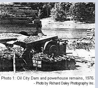
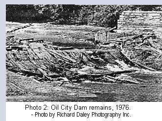
dam, are normally submerged. Both photos 1 and 2 (taken in 1976) are a view of the Oil City remains from the bottom
of the dam looking upstream on the Farmington River. They were also taken when the existing downstream Rainbow
Reservoir's water was lowered for maintenance.

A very similar view of photo 1 is in photo 3, which I took in September 2009. Comparing the photos of 1976 to
2009 reveals that the remains have deteriorated. In photo 3 there is a noticeable difference: what appears to be a roof or
floor above the powerhouse's turbine/generator assembly has collapsed to some degree. Also, to the right of the powerhouse
and stone abutment, some of the dam's timbers seen in photo 1 are not seen in photo 3.
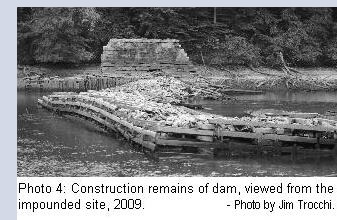
In 2009 (photo 4, taken slightly upstream from the dam's abutment) we can see that the logs and trap rock that
made up the dam between the abutments on the banks, and impounded the water, is still holding up well after 34 years.
The submerged logs are over 120 years old and well preserved. The trap rock may be from the abundant basalt quarries
on nearby Metacomet ridge.
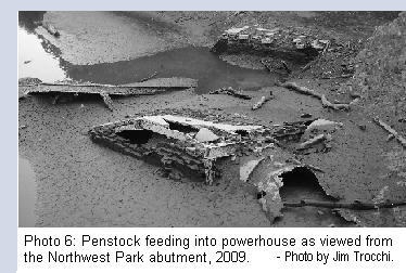
I took many photos of the submerged remains but probably the two photos I think most interesting, and perhaps
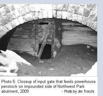
photographed for the first time ever, are photos 5 and 6. Photo 5 shows a sliding wood input gate in the arched
cavern at the bottom of the impounded NWP side's stone abutment. When this input gate was opened it allowed water
to flow in the penstock and turn the turbine/generator seen in photo 6. A penstock is simply a conduit to channel water.
With a 27-foot head of water, one can imagine the tremendous and efficient hydraulic force that went through the input
gate to feed that turbine. It was a remarkable engineering accomplishment in its day.
The reader may have wondered why the hydroelectric plant was named Oil City. In today's green revolution, this
partnership of words in the dam's title may seem like an oxymoron. But prior to the dam's construction, the area where
it was to be built was referred to as Oil City. It got its name because it is said that a confidence man from Pennsylvania
came to the area in the later part of the 19th century, bored a hole in a rock and filled it with a few barrels of oil, and told
everyone that oil was discovered in the area. To raise money for the venture he sold stock to those who believed his
scheme. He left town before his scam was exposed. Hence, the area became known as Oil City.
Searching the Historical Hartford Courant Newspaper database on iCONN brought up a couple of interesting articles
about the old dam. An April 12, 1890 article entitled "A Great New Project" announced the building of the electric
power plant. It was to include a 27-foot high dam to provide power to Hartford, over copper wires, to light streets
and power motors in factories there at great savings in cost. The plant was to produce 2,000 horsepower a day.
A second article that I found interesting was entitled "Power Plant Burned," and dated September 7, 1897. The
fire broke out at 2:30 in the morning because of a short circuit. The powerhouse burnt to the ground and, of course,
Hartford's downtown experienced a power outage - though only for 15 minutes because the Hartford Electric Light's
steam-powered Pearl Street plant was brought back online to provide the needed power until the hydro plant was rebuilt.
It also states that if additional power was needed because of the outage, there were big storage batteries at the rear
of the Courant.
At the conclusion of the Rainbow Dam's repairs, the great watershed of the Farmington River soon refilled the
Reservoir, and now only the Oil City stone abutments are visible. With the remains submerged again they should be
reasonably preserved. Perhaps in years to come the Reservoir's impounded water will be again drained and the thrill
of seeing the remains between the abutments will once again be a treasured event for industrial archaeologists.
Rainbow Reservoir can be reached by a short hike in Windsor's Northwest Park or by boat from a state boat
launch in the Rainbow section of town.
References:
• Roth, Matthew. An Inventory of Historic Engineering and Industrial Sites. Society of Industrial Archaeology,
Houghton, MI, 1981.
• Windsor Historical Society Newsletter, January 1995, volume 13 no. 1.