Selected Reprints
Summer Digs at Sherwood Island
by Ernie Wiegand and Cece SaundersIn celebration of the 100th anniversary of the Connecticut State Park system, the Friends of Sherwood Island
State Park received a grant from the State Historic Preservation Office of the Connecticut Department of Economic and
Community Development to conduct an archaeological survey of some of the historic sites known to have existed on Sherwood
Island. Norwalk Community College (NCC) professor Ernest Wiegand was hired to conduct the survey. NCC's Archaeology as an
Avocation Program alumnus and Yale archaeology graduate Dawn Brown assisted in the fieldwork and historic background
research.
The goal of the survey was to locate and investigate two of the early historic Sherwood family houses that existed on
the island as well as to discover any evidence of prehistoric Native American occupancy. The findings from the survey
would form the basis for a proposed historic trail system, providing educational and personal enrichment for park visitors.
The trail would include signage informing the visitor about the historic importance of each of the sites and/or structures
identified. It was also proposed that recovered artifacts might be used in public presentations and exhibits at the
Sherwood Island State Park Nature Center.
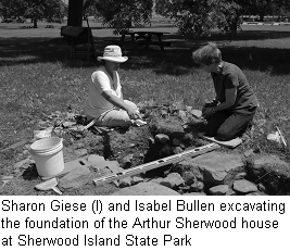
The first explored site was the Arthur Sherwood homestead, which was built at some time between 1868-1879. Arthur was
the grandson of Daniel Sherwood, who was the first of the Sherwood family to settle on the island. Daniel Sherwood built a
house there in 1787 after receiving two acres of land as a wedding present when he married Catherine Burr. Mr. Joseph
Elwood Betts, a longtime resident who is related to the Sherwood family, remembered summers spent as a young boy visiting
relatives at the Arthur Sherwood house and was able to pinpoint the site's location north of the Pavilion. Here, exposed on
the surface, were several fieldstones that were part of the house foundation. Mr. Betts has also authored a booklet, The
Sherwood-Elwood Connection, which provided an excellent introduction to the history of the Island. State Archaeologist
Nick Bellantoni and Debbie Surabian of the Natural Resources Conservation Service of the U.S. Department of Agriculture
conducted a ground-penetrating radar survey of the house site and the immediately surrounding area to detect anomalies
that may have been buried structural remains and/or features.
Excavations included a shovel test pit survey in the area surrounding the house foundation. While some 18th
century artifacts were recovered, the majority of the recovered materials were related to Arthur Sherwood and his family's
tenure and, later, to the use of the area as a picnic ground. Several of the test pits revealed that the land around the
house, which was demolished in the late 1930s, had been subject to disturbance. The discovery of a crushed shell roadway
was the most significant feature discovered during the survey. A larger excavation block was opened up at the approximate
center of the back wing of the house and revealed the upper portion of the foundation as well as a possible door step.
Most of the artifacts from this area were nails and window glass from the house, and were probably deposited in part during
the demolition of the house. The recovery of two Native American potsherds and several pieces of quartz lithic debitage
attests to the occupation of the site by Native Americans at some point during the Woodland period.
A second historic site was the Folly Farm site, located at the northern end of the Island. Originally the house of
Silas B. Sherwood, it later was occupied by Moses Sherwood and still later by non-Sherwood family owners until its removal
in the 1960s. Maps, photographs and documentary evidence indicated that not only was a house present, but support
structures including a barn, a large shed, a corn crib, and a windmill. Remains of the corn crib and the shed were exposed
on the surface of the site, and our work included uncovering several large fieldstone slabs associated with the shed.
Construction and domestic artifacts were found throughout the site.
The third site was the Sherwood Point site, located between the Pavilion and West Beach. It was on this beach that
NCC Archaeology Club member Barbara Tyburski found a fragmentary semi-lunar knife (or ulu) on the beach over twenty years
ago. As the artifact was not abraded by wave action, it was felt that it had only recently been eroded from the land above
the beach. Therefore, it was thought that there may be additional evidence of Native American occupation during the Late
Archaic period (c. 2500-3000 BC) in the area landward from the beach. Although only a few possible pieces of quartz
debitage were recovered, the survey showed that intact soil layers exist in this portion of the park, approximately 20-30
centimeters below grade. The buried topsoil layer in one portion of the site also contained historic materials from the
late 18th and early 19th centuries.
As of this writing, the field investigations are complete and a report detailing the study will be presented to the
Friends of Sherwood Island State Park this fall.
 The Friends of Sherwood Island State Park received support for the archaeological testing from the
State Historic Preservation Office of the Department of Economic and Community Development with funds
from the Community Investment Act of CT.
The Friends of Sherwood Island State Park received support for the archaeological testing from the
State Historic Preservation Office of the Department of Economic and Community Development with funds
from the Community Investment Act of CT.