Selected Reprints
Crossing the Connecticut River
by Jim TrocchiClick on each image to bring up a larger view.
Where did the first English settlers from Massachusetts Bay cross the Connecticut River? This is a question no
one knows for certain. We know they had to ford it at some convenient place and were possibly assisted by the
Native Americans, for there were no ferries or bridges. Today, within our state, the Connecticut River can be
crossed by eleven highway bridges, four railroad bridges and two ferries.
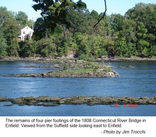
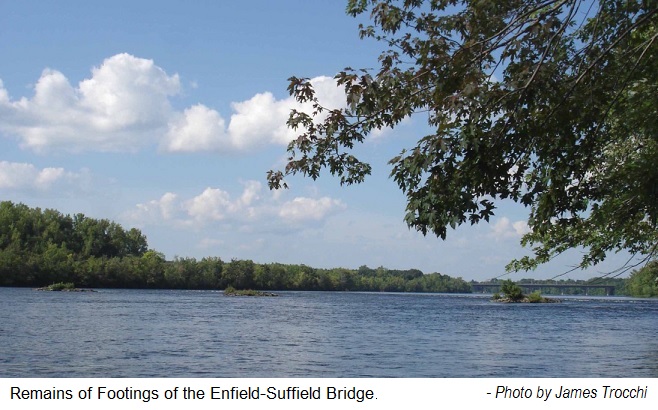 The first bridge across the River in Connecticut was built from Enfield to Suffield in 1808. Some of the
remains of this bridge (or its replacement) that once crossed here can be seen today. As shown in Photo 1, the
three islands you see in the middle of the river are the remains of the pier footings of the bridge. They line
up with Bridge Street in Suffield on the west side of the river and Bridge Lane in Enfield on the east side. The
present Connecticut Route 190 bridge can also be seen in the far background of Photo 1.
The first bridge across the River in Connecticut was built from Enfield to Suffield in 1808. Some of the
remains of this bridge (or its replacement) that once crossed here can be seen today. As shown in Photo 1, the
three islands you see in the middle of the river are the remains of the pier footings of the bridge. They line
up with Bridge Street in Suffield on the west side of the river and Bridge Lane in Enfield on the east side. The
present Connecticut Route 190 bridge can also be seen in the far background of Photo 1.
Construction for the Enfield Bridge began in 1796 and was completed in 1808. A newspaper article stated:
- "The General Assembly of 1796 gave to John Reynolds and his associates a charter to build a bridge to be
completed in 1805 and all rights to the bridge were given with the charter, which was one of the kind known as
close between the Massachusetts state line and the north line of the town of Windsor. The bridge was not built
at once, but in May, 1805 the time was extended for three years and in 1806 extended for three years more." (3)
Another article gives the north line of Hartford instead of Windsor as the southern border of the charter. (1)
The owners and their heirs of this charter were allowed "to collect tolls for either a period of 100 year or
until they collected the cost of the bridge plus 12 percent" (Miller 1998:p14). Furthermore, owners of this
charter had the rights to prevent anyone else from building another bridge, between the close area as stated
above, without considerations. The charter was tested when the Hartford and Springfield Railroad constructed a
bridge across the river at Warehouse Point. The courts ruled in favor of the Enfield Bridge Company, thus they
had to pay $10,000 to the charter owners to build their bridge at this location. Additionally, when the bridge
at Thompsonville was built, they paid $1200 to the charter owners and when the public bridge at Warehouse Point
was built they had to pay $3,000 to the charter owners (3).
The original 1808 bridge was not covered, "built without roof or walls to protect it from the harsh New
England weather, it quickly deteriorated and had to be replaced after it collapsed in 1821" (Miller 1998:p14).
The 1808 bridge was made from unseasoned timber and lasted only a short time before it fell into the river. A
replacement was authorized in the late 1820's and finally completed in 1832-33 at the same location. (3) The
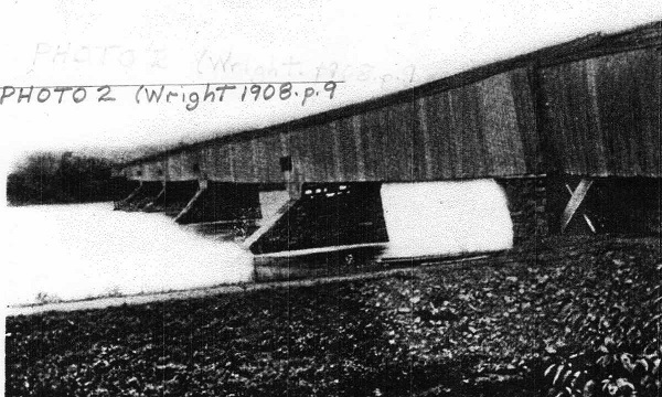
replacement was a 1000 foot long, 30 foot wide wooden covered bridge (Wright 1908:p9). This article further
mentions the building of a replacement bridge at Warehouse Point but lack of funds prevented this, and it was
eventually built in 1808 at the same location as the original. In order to raise money to build this bridge a
lottery was formed, "At that time a lottery was formed at a cost of a dollar a ticket, and the lucky holder of
the winning ticket was to have the bridge." (2) A U.S. Senator Dickson from Connecticut held the winning ticket
and became owner of the bridge and the charter. He and his heirs were the bridge owners until it's final days.
Other than by ferry, the bridge enabled farmers from Suffield to bring their produce to the village of
Thompsonville, "which is a market of great share of their produce". (2) Photo 2 shows the 1832-33 bridge taken
from the Suffield side and the towpath of the Windsor Locks Canal can be seen in the foreground. The Enfield
side can be seen in the far distance with the toll house jutting out from the bridge. In this photo you can also
see the four piers in the water where today we usually only see the remains of three. Depending on the height of
the river, the remains of the fourth pier may be visible at times of low water.
 By the mid 1890's the bridge revenue and usage declined. "Mr. Keach, the present toll keeper, says that the
bridge is very lightly patronized." (2) By this time, this bridge, the one in Thompsonville and the one in
Windsor Locks were three of the seven remaining toll bridges in the state (6). "One thing is for certain, that
the next Legislature will be asked to take control of the three remaining toll bridges of the state, of which
this is one." (2) This article goes on to say that the owner of the historic bridge was anxious to abolish the
tolls and sell it. Finally, around 1897 the bridge's entrances were boarded up but "Pedestrians and bicyclists
loosened enough boards to allow passage and that was all the travel upon the bridge for over three years." (3)
By the mid 1890's the bridge revenue and usage declined. "Mr. Keach, the present toll keeper, says that the
bridge is very lightly patronized." (2) By this time, this bridge, the one in Thompsonville and the one in
Windsor Locks were three of the seven remaining toll bridges in the state (6). "One thing is for certain, that
the next Legislature will be asked to take control of the three remaining toll bridges of the state, of which
this is one." (2) This article goes on to say that the owner of the historic bridge was anxious to abolish the
tolls and sell it. Finally, around 1897 the bridge's entrances were boarded up but "Pedestrians and bicyclists
loosened enough boards to allow passage and that was all the travel upon the bridge for over three years." (3)
The most interesting tale about this bridge occurred on February 16, 1900, when a freshet carried three of
its spans away. On the Enfield side of the bridge was a toll house and the Enfield bridge station of the New
York, New Haven and Hartford Railroad. The station agent and bridge tender was a man named Hosea Keach and he
nearly lost his life that day. (5) An article reported Keach:
- "had orders since the rise of the Connecticut River this week to keep a close watch on the bridge and
inform the authorities whenever he thought there was imminent danger of its breaking away from its piers, that
proper precautions might be taken for the protection of the railroad bridge at Warehouse Point, two and a half
miles below. Mr. Keach had been upon the bridge several times during the day yesterday and had given such
inspection as he thought necessary. Shortly after 2 o'clock he made a trip to it that he will never forget,..."
(3).
In Mr. Keach's own words:
-
"I was about two thirds of the way to the first pier on the eastern span of the bridge, when I heard a crash
like falling timber and without stopping to look in the direction I knew the central span of the bridge had
gone into the water. I turned and made for the shore end of the bridge as fast as I could run, but before I
could make it, although I was within eight or ten feet of land, the span shut up like a jackknife, the timbers
of the bridge in front of me rising in the air, apparently getting ready to fall upon top of me" (3).
At this point Keach said he was in an unconscious state and couldn't remember for how long, but when he
became conscious he found himself sitting on a crosspiece of the upper section of the bridge, 'high and dry'.
(3) He went on to tell of being trapped in the bridge span with roaring water below. Although trapped inside
he tenaciously found an opening and pried it open enough to get his head out and find his bearings. The current
and wind were in favor of taking him downstream, perhaps to Long Island Sound. Keach managed to dislodge an old
sign, that read Walk Your Horses Across This Bridge, and crawled onto the bridge's roof and began to shout for
help. Two railroad workers at the Warehouse Point Station heard his cries and recognized him. They ran to the
store house and gathered up a rope. They next went out on the railroad bridge and as the "ark of ruin" floated
by, they dropped the rope over Keach and pulled him 12 to 14 feet to the safety of the bridge. (3)
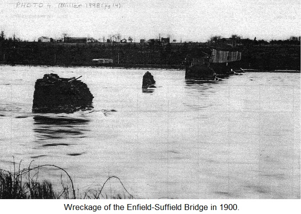 During the February 1900 freshet, three spans were destroyed and only the two on the Suffield or west side
remained. (Photo 4) The three span wreckages were a concern for the safety of bridges to the south and to
river traffic. One span hit a pier and was torn up between the railroad bridge at Warehouse point and the
travel bridge in Windsor Locks. The other spans passed Windsor Locks and one was finally secured at Bissell
Ferry in East Windsor. (3) Two spans were reported lodged on the bank in East Hartford. (4). What may have been
reported as spans, may have been partial spans and hence more than the actual three.
During the February 1900 freshet, three spans were destroyed and only the two on the Suffield or west side
remained. (Photo 4) The three span wreckages were a concern for the safety of bridges to the south and to
river traffic. One span hit a pier and was torn up between the railroad bridge at Warehouse point and the
travel bridge in Windsor Locks. The other spans passed Windsor Locks and one was finally secured at Bissell
Ferry in East Windsor. (3) Two spans were reported lodged on the bank in East Hartford. (4). What may have been
reported as spans, may have been partial spans and hence more than the actual three.
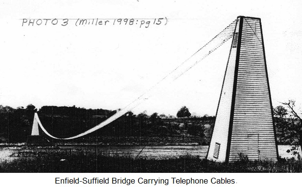 This bridge also carried the telephone cables across the river to Enfield and beyond, therefore
communication service was lost to this area as a result of the February 1900 freshet. (3) By 1901, the Southern
New England Telephone Co. bought the bridge and charter rights and had the two remaining spans dynamited. They
reported that in a short time they will build a passenger footbridge that will also carry its telephone wires
(5). During the demolition it was realized that the lumber was reusable. "The pine lumber in the bridge is
practically as good as new when it was put in and Superintendent Sperry estimates that from 20,000 to 40,000
feet of pine lumber will be saved and used again." (5) From the Enfield side, Photo 3 shows the two telephone
towers and the cable strung across the river but no foot bridge. For comparison, I also looked at a 1934 aerial
photo, under full zoom, and the remains of four pier footings are clearly visible but no evidence of a
footbridge or the telephone towers and cable crossing the river. Therefore, sometime after 1901 and before 1934,
the towers and cable arrangement were eliminated.
This bridge also carried the telephone cables across the river to Enfield and beyond, therefore
communication service was lost to this area as a result of the February 1900 freshet. (3) By 1901, the Southern
New England Telephone Co. bought the bridge and charter rights and had the two remaining spans dynamited. They
reported that in a short time they will build a passenger footbridge that will also carry its telephone wires
(5). During the demolition it was realized that the lumber was reusable. "The pine lumber in the bridge is
practically as good as new when it was put in and Superintendent Sperry estimates that from 20,000 to 40,000
feet of pine lumber will be saved and used again." (5) From the Enfield side, Photo 3 shows the two telephone
towers and the cable strung across the river but no foot bridge. For comparison, I also looked at a 1934 aerial
photo, under full zoom, and the remains of four pier footings are clearly visible but no evidence of a
footbridge or the telephone towers and cable crossing the river. Therefore, sometime after 1901 and before 1934,
the towers and cable arrangement were eliminated.
 The bridge remains can be viewed from both sides of the Connecticut River (Photo 5). On the west side they
can be reached by heading south at the intersection of the Connecticut Route 190 bridge and Route 159, take your
first left onto Canal Road and follow it to the end. Park at the state parking lot and follow the canal path
south for about three-fourths of a mile. On the east side they can be viewed by going south from the Connecticut Route 190
bridge on US Route 5 for about a mile. Take a right onto Bridge Lane and follow Bridge Lane, across the railroad
tracks and park by the side of the road. The best view of these remains is from the Suffield side when the
foliage is off the trees and the water level is low.
The bridge remains can be viewed from both sides of the Connecticut River (Photo 5). On the west side they
can be reached by heading south at the intersection of the Connecticut Route 190 bridge and Route 159, take your
first left onto Canal Road and follow it to the end. Park at the state parking lot and follow the canal path
south for about three-fourths of a mile. On the east side they can be viewed by going south from the Connecticut Route 190
bridge on US Route 5 for about a mile. Take a right onto Bridge Lane and follow Bridge Lane, across the railroad
tracks and park by the side of the road. The best view of these remains is from the Suffield side when the
foliage is off the trees and the water level is low.
Bibliography:
1998 Miller, Michael K., Images of America, Enfield, Connecticut
Arcadia Publishing
Charleston, SC, Chicago, IL, Portsmouth, NH, San Francisco, CA
1908 Wright, George E.,Crossing the Connecticut, The Smith-Linsley Company, Hartford, Conn.
Hartford Courant. ICONN.org - Newspapers - Hartford Courant _ Historical (1764-1922)
(Provided by ProQuest)
(1) 18 Jan. 1882
(2) 17 Dec. 1894
(3) 16 Feb. 1900
(4) 17 Feb. 1900
(5) 21 Aug. 1901
(6) 3 May 1887
CT Digital Collections. ICONN.org - Aerial Survey of CT, 1934, photo 07821