Selected Reprints
Windsor's Palisade
by Jim Trocchi A palisade is a barrier or fortification made of strong timbers set in the ground and built in a stockade fashion.
Plymouth Plantation and sketches of the Jamestown settlement are examples of these stockade structures built to protect
an enclosed village. It could be said that these were probably the most architecturally significant structures of
mid 17th century New England. In Connecticut we have reports of palisades built in strategic locations of early settlements.
Along the Connecticut River, for example, the English built palisades in Saybrook and Middletown, and the Dutch built one
in Hartford. Their purpose was for protection from the Native Americans who clearly outnumbered the colonists at the time.
Further up the Connecticut River in Windsor was a palisade that is very significant because, unlike the many palisades
that have oral tradition and maybe archaeological evidence, this palisade has a primary written source describing
it. The reason we have this valuable record today is because the General Court in September 1639 enacted that every
town in the colony should choose a town clerk or register and by the next April record every man's house and land already
granted and measured out to him (Stiles 1891:133). Windsor's town register was Mathew Grant, who is a direct ancestor of
General and President U. S. Grant. A copy of Grant's extract of the Palisade can be seen in either of the publications in
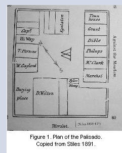
the bibliography below. The map in Figure 1, entitled "Plan of the Ancient Palisado" is what Grant was recording in 1654.
The site of the palisade is north of Windsor center, immediately as one crosses the Route 159 Farmington River
bridge. Its area was rhombus in shape covering a perimeter of approximately 4300 feet. It is strategically located one
mile up from the Farmington River's confluence with the Connecticut River. At this mile point the river meadows
first give way to a high prominence of land. Even before the colonists came, the Native Americans must have valued the
advantages of this location.
The soil stains remains or evidence of palisades have been found in the 20th century archaeological record in
places, such as the Jamestown area, but none that I know of have a primary historical record to accompany them. To the
contrary, the Windsor Palisade has this marvelous written record but no archaeological evidence to go with it. The
only possible archaeological evidence we have of the Windsor Palisade was mentioned by Henry Stiles in his 1891 edition
of The History of Ancient Windsor

"This south line was 60 rods long; and along the south side of the passage leading from the meeting-house to the
burying-ground are now [1891] to be seen the remains of a ditch, believed to have been a part of the south line of the
fortification" (Stiles 1891:136).
Point A on the map in Figure 2, entitled "Walk the 1637 Pallizado," is the approximate area to which Stiles is
referring. Because of the expansion of the cemetery and additions to the First Church in the palisade's southwest corner,
the remains Stiles observed probably have been destroyed.
In the last twenty years, I personally know of several attempts to find archaeological evidence of the palisade's
remains. The first was in 1986 when the Route 159 bridge was to be replaced and a state-mandated archaeological study
was required. Test pits were dug on the Farmington River's north bank end of the bridge right of way (Figure 2, point
E). This area of study has been severely excavated over the last two centuries because of bridge replacements and road
improvements. Hence, evidence of the palisade was not found.
In the fall of 1994, with permission of the property owner, a trench was dug on the southeast corner (Figure 2,
point B) of the palisade, with no positive results. Except for some lithic flakes, no artifacts relating to the palisade
time period was found.
Later, in the fall of 1998, I got permission from another landowner, whose property borders the riverbank just to the
right of the Farmington River bridge when heading north on Route 159. During this event, two one-foot wide trenches
were dug starting at the crest of the riverbank, (Figure 2, point C), and into the bank for a depth of 38 inches and a
length of 12 feet for trench 1, and 5 feet for trench 2. Again, no archaeological trace was found.
The FOSA crew came by in the late 1990s and dug in the northwest corner of the palisade. They cut a long trench
in this area (Figure 2, point D) with no results.
Evidence of the Palisade's remains would be a wonderful accomplishment, no matter how small a feature that is
found. Hopefully, we will get other permissions from other private landowners on the palisade's boundaries. It would
be a treasure for not only Connecticut's oldest settlement to behold but also for all Connecticut and New England.
Bibliography
Howard, Daniel. Glimpses of Ancient
Windsor. Windsor Tercentenary
Committee, 1933.
Stiles, Henry. The History and Genealogies
of Ancient Windsor, 1891. Press of the
Case, Lockwood and Brainard Company,
Hartford, CT.