Selected Reprints
Corduroy Roads
by Cece Saunders, Historical Perspectives, Inc.email: hpix2@aol.com, 203-226-7654
How did man, horse and wagon traverse the mud, muck, and marshes that so often surrounded our earliest
coastal towns and river settlements? Without the modern benefits of steel and concrete that create reliable bridges,
how did the 18th century road builder span those wet and muddy stretches?
A corduroy road is a type of road made by placing whole logs perpendicular to the direction of the road over a
low or swampy area. Sand is used to form a base for the logs and to cover them once they are in place. There were
various methods used to keep the logs from slipping under the impact of hooves and wheels. The result is an improvement
over impassable mud or dirt roads, yet it provides a decidedly bumpy ride in the best of conditions and a hazard
to horses due to loose logs that can roll and shift. This type of road was already constructed in Roman times. It is known
to have been used as early as 4,000 BC with examples found in bogs in England and still constructed in the 20th century
in Alaska.
The corduroy road was essential for establishing networks between communities and critical resources during
the 18th century in New England. Town minutes and archaeological reports document the use of corduroy roads
during this period. Records are clear that Washington's troops built corduroy roads in order to create shortcuts over
marshy areas, moving vast numbers of troops and supplies quickly.
There are at least two known surviving examples of 18th century corduroy roads in Connecticut. One is the Chittenden
Beach corduroy road that rests beneath salt marsh peat in Guilford. This road is pictured in Robert Gordon's History
of Sea Level Changes along the Connecticut Shore (1983).
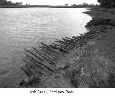
The second, the Ash Creek corduroy road in Fairfield, appears to be the oldest remaining example of a preserved
wooden road in the state. Today, a relatively intact 53-foot section of this road is visible during low tide in Long Island
Sound. The log road, composed of local species (oak, maple, black birch, etc.), rests between 30 to 36 inches below
grade, which is dominated by a thick mat of cord grass. It survives as a remnant of a colonial road system that was crucial
to the early development of Fairfield.
In ca. 1750, local resident Peter Penfield constructed a tidal grist mill and a dam at the mouth of the Ash Creek. At
approximately the same time, a corduroy road was constructed along the edge of the Ash Creek salt marsh that
connected with a bridge over the narrowest section of the Creek. The road and bridge linked an old Fairfield town road, the
Penfield mill, and the community of Black Rock, a section of what is now Bridgeport. This access way not only allowed for
the transport of raw materials and products to and from the mills, it provided a much needed short cut across the Ash Creek
from the colonial Fairfield town center to Black Rock Harbor.
This archaeological resource was brought to the attention of the state initially by Kruger Frank, an archaeologist
from the Fairfield area that used to walk his dog along the Ash Creek shoreline. Through the cooperation of the Connecticut
State Historic Preservation Office, the Town of Fairfield, and the Aspetuck Land Trust, the Ash Creek Corduroy Road has
been listed on the State Register of Historic Places and is now designated as a State Archaeological Preserve.
We are collecting additional data on corduroy roads and their prevalence in the state. Do you have any evidence of a
corduroy road in your section of Connecticut? If so, please share the information with us.