Selected Reprints
Connecticut Indian Demographics at European Contact
by Jim Trocchi The following is a revision of a paper I did many years ago. It is based on primary, secondary and literary
resources along with anthropological studies to produce a monograph of what the Connecticut human landscape was like
when the first Europeans, mostly English, first stepped foot on this land.
INTRODUCTION: All the aboriginal inhabitants of Connecticut are classified as Algonquian, a group of people
living along the Atlantic coast from the present day Maritime provinces of Canada to the Carolinas. They all spoke
a distinct language that varied in dialect from group to group.
Within the boundaries of present-day Connecticut lived various groups or bands of Indians. Because of their social
organization, reference to tribes of Indians doesn't seem to be technically valid in southern New England, according to
Bert Salwen (1978): "Above the village level, multi-village alliances undoubtedly played an important role, but it is not
really clear if these were enduring or highly structured enough to be classified as true 'tribes.' Pre-1620 descriptions
of eastern Massachusetts social units generally speak only of individual villages or loose groupings of villages"
(Salwen 1978:167).
POPULATION ESTIMATES: Total population estimates between 1600-1650 for all these groups and bands of
Indians inhabiting Connecticut prior to European contact range from 6,000 to 20,000. The higher population figures
were abstracted from John Winthrop's Journal (1630-49), which gives a figure of 12,000 to 15,000, and John Trumbull's
history (1926), which gives a figure of 16,000 to 20,000. Lower population figures of 6,000 were given by
John De Forest (1851:45-68) and Forest Morgan (1904:48-49). Sherburne Cook used other criteria besides historical
records. He took into account primitive family size, number of people residing in a dwelling, the area a village
encompassed and the amount of food grown or gathered. From his analysis, he estimates the population to be close to
10,000 total individuals.
There are newer studies that may have come up with different population estimates for this 1600-1650 time period and
for the various groups discussed below. In the near future I hope to review and report any dramatic differences to you.
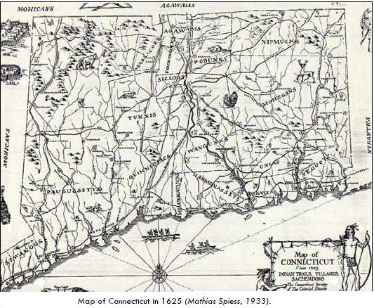
TERRITORIES: Reference the accompanying 1625 Connecticut map (Spiess 1933) as you read the following. The major bands
of Connecticut Indians can be divided into four major regions of the state. Those living in the southeastern region
of the state along the shore were the Western Nehantics, Mohegan-Pequot and possibly the East Nehantic. Another
region is the northeast where a sparse population of Nipmucks lived. Next we have the River Indians in the central
region living close to the Connecticut River Valley and its tributaries, from the Massachusetts line to Long Island
Sound. The last bands we will discuss resided west of the Connecticut River, along the shore, and comprised the
Quinnipiacs, Hammonassetts, Paugussetts and Siwanogs. The only large area that is not mentioned as having any inhabitants
is the northwest area of the state, because there has been no convincing evidence of indigenous Indians living
here at the time of European contact, with the exception of roaming Mohawks or hunting parties.
"[T]he country now known as Litchfield County, together with the northern part of Fairfield and the western part of
Hartford counties, presented an uninhabited wilderness. The birds built their nests in its forests, without being disturbed
by the smoke of a single wigwam; and the wild beasts, who made it their home, were startled by no fires save those of a
transient war-party, or a wandering hunter" (De Forest 1851:51). In contrast, John Swanton says that "The northwest corner
of Litchfield County was occupied by the Wawyachtonoc, a tribe of the Mahican Confederacy of the upper Hudson, though their
main seats were in Columbia and Dutchess Counties, N.Y." (Swanton 1953:29)
In the southeast region of the state, east of the Connecticut River along the shore (the present day town of
Lyme), lived the Western Nehantics. Their territory went as far east as the Nehantic (Niantic) River, had a population
estimated at 250 (Salwen 1978:169), and their earliest sachem known to us was named Momojoshuck, followed by Ninigret
(De Forest 1851:180).
The Mohegan-Pequots were the most numerous of the Indians in Connecticut and perhaps the most destructive
and oppressive. The following excerpt is in reference to Connecticut Indians traveling to Plimouth Plantation seeking
English assistance. "But afterwards ther coming a company of banishte Indeans into these parts, that were drivene
out from thence by a potencie of ye Pequents, which usurped upon them to drive them thence ..." (Bradford
1908:371). In addition, "The most terrible of all those Nations were the Pequot: who with their depending Tribes
soon entered on a Resolution to Destroy the English out of the Country. In 1634, they killed Capt. Stone and all his
Company, being seven besides himself, in & near his bark on the Connecticut River. In 1635, they killed Capt. Oldham in
his bark at Block Island; and at Long-Island they killed two more cast away there. In 1636, and the following Winter and
March, they killed six & took seven more at Connecticut River: Those they took alive they tortured to Death in a most
barbarous Manner. And on April 23, 1637, they killed nine more and carried two young Women Captive from Wethersfield"
(Capt. John Mason 1736:iv by Rev. Mr. Thomas Prince).
The Pequot territory went "from the Niantic River on the west, their forts and wigwams extended along the rude
and stony hills of New London County to Wecapaug, ten miles east of the Paucatuc River that divides Connecticut
and Rhode Island" (De Forest 1851:58). This roughly encompassed the present-day towns of New London, Groton, Mystic and
Stonington along the shore and inland north 15 to 20 miles.
It has been written that Pequot tradition speaks of them migrating into Connecticut from the Mid-Hudson Valley
as late as the turn of the 17th century (Rainey 1936:6). This tradition has been debated by anthropologists because
of later archaeological and linguistic findings (Snow 1980:331)
By 1640 the Pequots split because of a disagreement in who would succeed as sachem (Rainey 1936:7). De Forest
(1851:66-67) gives the genealogy of Uncas' family as given by himself in 1679. In it, Uncas claimed to be a great-grandson
on his mother's side of Tamaquashad, chief of the Pequot at the time of their invasion of Connecticut. "Dr. Speck (1909:184)
states that the two tribes were linguistically identical and formerly, if not a single people, were at least
very closely related tribes" (Rainey 1936:7). Thus, the territory was split between the two groups around the English
contact period, with the Pequots in the south and the Mohegans in the north at the present day City of Norwich under
their sachem, Uncas. The population estimates of both groups at contact were 4,000 warriors (Gookin 1675:7), although
Mooney has their total population around 2,800 (Salwen 1978:169).
Some important names of prominent Pequots up to the contact period were Tamaquahad, the earliest sachem known
to us. Muckquntdowas followed him; he in turn was succeeded by his son Woipeguand, who in turn was also succeeded
by his son Wopigwooit, their sachem at the initial contact time.
One last band in the southeast that is mentioned in the literature is the East Nehantics. It is possible that if the
Pequots came into Connecticut at the turn of the 17th century from New York, they settled in the territory previously held
by the Nehantics. This split the Nehantics into an east and west group with the east group settling in Rhode Island with
the Narragansetts. "Of these, the Western Nehantic are undoubtedly a distinct group as they were cut off from the
Eastern Nehantics by the Pequot invasion and closely resemble the Narragansett" (Rainey 1936:8).
In the northeast part of the state in Tolland and Windham counties were the Nipmucks. Their territory extended
into Connecticut but their principal seat was in Massachusetts (De Forest 1851:57, Rainey 1936:7). The population of
the whole Nipmuck group is said to be about 500 (Salwen 1978:169). Therefore, if we proportion it to their total territory
in Massachusetts and Connecticut, I speculate those residing in Connecticut alone could probably be no more than maybe 50.
Moving into the central portion of the state, north up the Connecticut River, were several River Indian bands.
Some 8-10 miles west of the Connecticut River along the Farmington River were located the Tunxis or Sepores Indians (Morgan
1904:50). Their territory was the present towns of Farmington, Southington, most of New Britain, and Berlin, Bristol,
Burlington, Avon and Plainville. Their population was estimated at about 400 (Salwen 1978:169). North of the Tunxis was a
small area occupied by a band called the Massacoes in the present towns of Simsbury, Canton, and parts of Granby, East
Granby, and Barkhamsted. Their principal village was Weatogue (Spiess 1933:20). This group is referenced in the early
Windsor land deeds (1642:195) as Poquonock, where their sachem Nassahegan refers to them as his western boundary.
About 5 miles west of the mouth of the Farmington River is said to be the main camp of the Poquonocks.
Their territory was essentially present day Windsor, Windsor Locks, and parts of East Granby and Bloomfield. Besides
their main village they also had a village known as Matianuck that was the area south of the mouth of Farmington
River and stretching to Hartford (Spiess 1933:27). Matianuck is mentioned in the Windsor land deeds (1670:227)
but originally purchased in 1633. The Poquonock sachem at contact time was Sheat or Seheat.
Closely related to the Indians of Windsor but living on the east side of the Connecticut River from them were the
Podunks. It is believed that they had the largest Indian village in the state, covering several hundred acres (Spiess
1933:1). The heavy concentration of artifacts that have been found there indicates this. Many are displayed at
South Windsor's Wood Memorial Library. Their territory was bordered on the west by the Connecticut River, and
ran east to Bolton, north to East Windsor and south to Glastonbury. Their population was estimated to be in the
realm of 300 (Salwen 1978:169). The 300 figure may also include the Poquonocks, since the above reference is not
clear. Their sachem at contact time was called Nattawanot.
North of the Indians of Windsor were the Agawams from Massachusetts. Their territory was in the present
towns of Suffield, Hartland, Granby, East Granby, Enfield and east to Nipmuck country.
Just south of the Windsor Indians at Matianuck were the Indians who populated Hartford, called the Saukiogs or
Sicaogs. Their chief sachem when the English arrived was Sequassen, son of Sequin. The deeds showing that Sequassen
sold land in the Tunxis territory to Europeans implies that Sequassen held the allegiance of the Tunxis (Spiess 1933:18).
South of Hartford were the Wangunks, whose territory was on both sides of the Connecticut River, from Wethersfield
to Middletown on the west side and Glastonbury to the country of the Western Nehatics (Lyme) on the east side. Their
population was estimated at around 400 (Salwen 1978:169).
In the southwestern region of the state resided the Quinnipiacs, who "extended along the shore from Milford
to Madison; holding the bay of New Haven and the little rivers that emptied into it as fishing places" (De Forest
1851:48). In simpler terms, their territory comprised the present towns of Meriden, Cheshire, Wallingford, Hamden,
North Haven, East Haven, New Haven, Branford, North Branford and parts of Bethany, Prospect, New Britain and
Waterbury. According to De Forest's research in the records of New Haven Colony, when their land was sold in
1638 their population was about 200-250, and of these 47 were 47 (De Forest 1851:48). The Quinnipiacs are also referred
to by the name Quiripi. Momauquin was the sachem of this group at contact time.
A small band that resided along the shore in a little territory east of the Quinnipiacs was the Menunketucks. They
were governed by a squaw sachem named Shaumpishuh, a sister to Momauquin, sachem of Quinnipiac. According to
Guilford records their population was comprised of 14 men, 6 women and 14 children when they sold their land to the
Europeans (Spiess 1933:29). The band's territory included the towns of Guilford and most of Madison.
Also on the shore, east of the Quinnipiacs and the Menunketucks, stretching to the Connecticut River were the
Hammonassetts. The present towns of Saybrook, Essex, Old Saybrook, Westbrook, Clinton, and part of Killingworth
were their territory. According to De Forest (1851:52) their population was few in number.
Paugussetts inhabited the present day towns of Monroe, Huntington (Shelton), Trumbull, Bridgeport, Stratford, Milford,
Orange and Derby, encompassing the lower Housatonic and Naugatuck River Valleys. Their territory estimate
is based on information from land deed sales made by the Paugussetts (De Forest 1851:49-50). This group also includes
as many as five other bands in the vicinity, known along the shore as the Wepawaugs and Unkowas, and further
inland to the north along the Housatonic and Naugatuck Rivers as the Potatucks, Pomeraugs and the Naugatucks.
The population of all of them is estimated to be about 400 (Salwen 1978:169).
Down in the southwest panhandle of the state was a group from present-day New York called the Siwanogs.
"An old Dutch map of about 1614, published in New York Document Collections of History, I (1856), shows western
Connecticut occupied by a group of Indians designated as 'Makimanes.' Writing in 1625, (de Laet 1811:296), distinguishes
a group of Indians along the southwestern shore of Connecticut as 'Siwanoos ...'" (Rainey 1936:8).
In conclusion, I have referred to the political organization of Indians in the state as either groups or bands
depending on their population. It appears that most of those mentioned do not go beyond the ranking of bands, which
are defined as a set of nuclear families that regularly live and travel together. On the other hand, tribes are defined as
a set of extended families or lineages that regularly reside together for at least part of the year. The Mohegan-Pequot
is the only group at this time that might be considered a tribe.
• Bradford, William. 1620-1637 History of Plymouth Plantation Edited by S.E. Morrison, 1908 edition
• Cook, Shelburne. The Indian Populations of New England in the 17th Century. University of Cal. Publication in Anthropology V.12, Univer of Cal. Press, Berkley and L.A.: 1976.
• De Forest, John. History of the Indians of Connecticut. Wm. Jas. Hamersley, Hartford, CT: 1851.
• de Laet, John. Extracts from the New World or a Description of the West Indies, 1625. New York Historical Collections, n.s. vol. 1. New York: 1811.
• Gookin, Daniel. Historical Collection of the Indians of New England. Arno Press, New York: 1972.
• Morgan, Forest. Connecticut As a Colony and as a State. The Publishing Society of CT: 1904.
• Mason, John. A Brief History of the Pequot War. Printed and sold by S. Kneeland & T. Green in Queen St, Boston, MA: 1736.
• Rainey, Froelich G. Bulletin of the Archaeological Society of Connecticut. Published by the Society, New Haven, CT: 1936.
• Salwen, Bert. Indians of Southern New England and Long Island: Early Period. In Handbook of the North American Indians, Vol. 15. Smithsonian Institute, Washington, DC: 1978.
• Snow, Dean R. The Archaeology of New England. Academic Press, New York: 1980.
• Spiess, Mathias. The Indians of Connecticut. Tercentenary Committee of CT, Comm. of Historical Publications: 1933.
• Swanton, John R. The Indian Tribes of North America. Bureau of American Ethnology, Bulletin 145, Washington, DC: 1953.
• Windsor Land Deeds, Volume I, Windsor, Connecticut.
• Winthrop's Journal, Vol. I, II. History of New England 1630-1649. Charles Scribner's and Sons, NewYork: 1908.