Selected Reprints
Updates From Mashantucket
by Mandy Ranslow This article is a glimpse of the many projects undertaken at the Mashantucket Pequot Museum and Research Center during
the summer and fall of 2009. The first two articles discuss features excavated at Sandy Hill and site 72-277. The third
article is an update on the "Battlefields of the Pequot War" Project.
- Mandy Ranslow
While primarily known as an Early Archaic site comprising of a series of pithouse features, Sandy Hill, located
on the Mashantucket Pequot Reservation, is beginning to reveal a more complex sequence of occupations. Ongoing
excavations have yielded a series of large pit features which AMS dating reveal to be part of the Early to Middle Woodland
period. The circular pits measure up to two meters deep, share a complex set of strata nearly identical in each
feature, contain a central post mold at the bottom, and are completely devoid of artifacts. Once thought to be peripheral
to the site, their sheer volume (over a dozen have now been identified) point towards a significant Woodland presence
at Sandy Hill.
Past excavations have yielded more questions than answers as to the nature and function of the features, so when
one was discovered in the middle of a proposed pipeline route in the summer of 2009, it was hoped that new excavations
would produce some resolution. The results have not disappointed. Shortly after the discovery of the pit, a second
identical feature was found adjacent, and it is likely the two overlapped. A singular oval ring of post molds, extending
over a meter and a half into the ground was also discovered to have encircled both features. A large ground stone pestle
found in the first feature provides the first confirmed artifact any of the pits has yielded. The morphology of the
features compares favorably to Late Woodland storage pits found at the Tocks Island Site in the Upper Delaware Valley,
excavated by Herbert Kraft in the 1970s. In addition, a projectile point found adjacent to the two features bears a close
resemblance to the "Tocks Island Point," a regional Mid-Atlantic point type. While the 2009 discoveries have broadened our
understanding of the Woodland occupation of Sandy Hill, additional research and excavations will be required to fully
comprehend the nature of this settlement and its associated features.
- Noah Fellman
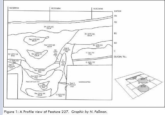
Excavations at site 72-277 on the Mashantucket Pequot Reservation have been completed after two years. Feature 9
was discovered and excavated over a period of six weeks. It encompassed an area two meters in length and three meters in
width. The deepest portions of the feature extended to a depth of over 100 centimeters, where it reached sterile glacial
soils and ended abruptly (Figure 1).
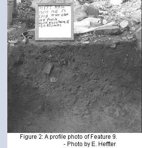
Feature 9 was initially noticed as a bright orange soil discoloration about 20 centimeters below surface (cmbs).
This soil discoloration was bisected in a north to south orientation in order to determine its depth. The bright
orange discoloration ended around 40 cmbs, while a bowl shaped black-brown soil discoloration continued until
about 73 cmbs. The feature was then bisected east to west to further determine its extent. This portion of Feature 9
contained artifacts consisting of argillite, quartzite and chert flakes, as well as high concentrations of wood charcoal.
The bisections revealed that the feature continued to the south and east of the original excavation area. This part of
the feature differed from the original portion. No orange soil discolorations were present and the feature became larger
and bowl shaped (Figure 2). Some areas of the feature had bands of soil that alternated between dark brown soil
(similar to other parts of the feature), and sterile, gravelly sandy soil. Few artifacts were found in this portion of the
feature, save for high concentrations of wood charcoal and a few charred botanicals. This feature appears to consist of
two components. The portion of the feature containing the alternating bands of soil may be the remains of a tree throw.
The portion of the feature with the bright orange discoloration (which indicates burning), may have been the location
of a hearth.
- Eric Heffter 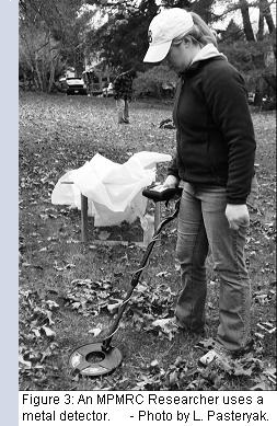
The Mashantucket Pequot Museum & Research Center continues its endeavors in the "Battlefields of the Pequot
War" project, funded by the National Park Service Battlefield Protection Program. This past fall, the museum began
metal detection and archaeology in Mystic, Connecticut, working to uncover battlefield artifacts at Porter's Rocks,
where English and Native troops camped the night before the battle at Mystic Fort, and at Pequot Hill, the site of Mystic
Fort. Document and material culture research continues to uncover new facts about the Pequot War, including new
primary source narratives, additional English and Native veterans previously unknown to researchers, and insights into
17th century sites in Connecticut. Plans for 2010 include resuming battlefield archaeology at the sites in Mystic,
continued document research, and the launch of a new "Battlefields of the Pequot War" project website. For more
information about the project, please call (860) 396-6868, or email Dr. Kevin McBride at kmcbride@mptn.org.
- Laurie Pasteryak